
It is obvious that I like to hike. Although hiking has been the topic in only two of my forty-six posts, it has been a topic in fifteen more.
Exactly one year ago I wrote about four walks to waterfalls in a particular area of North Carolina. In selecting them, my only criteria were “that they be easy enough for a family with kids to complete” and “that the drive from town to trailhead not take more than several minutes.”
Today I have decided to write another post about family-friendly hikes, but without confining myself to one area and without requiring that the trails be close to town. So here, in alphabetical order, are four of my favorite easy hikes in America -- and it is pure coincidence that once again, waterfalls are seen on all of them:
Abrams Falls Trail, Tennessee
At 2.2 miles one-way and 4.4 round-trip, this is the longest walk I will mention here, and if your kids are younger than seven or eight you might end up carrying them part of the way. The trailhead is located approximately five miles onto the Cades Cove Loop Road in Great Smoky Mountains National Park, and the trail parallels the course of Abrams Creek while following a series of modest undulations up to a low ridge. After attaining the ridge, it switches back and descends the other side to where the waterfall awaits.
Abrams Falls is only 20 feet tall, yet it carries an enormous amount of water that makes it more striking than some falls that are much taller. And that water plunges into a deep pool that is one of the best swimming holes in the mountains, so if you make this hike on a hot summer day, feel free to jump in and cool off. While you’re at it, keep an eye out for otters swimming in the stream and playing on the banks. Just be sure not to walk on the rocks, which are very slippery and have led to many injuries over the years.

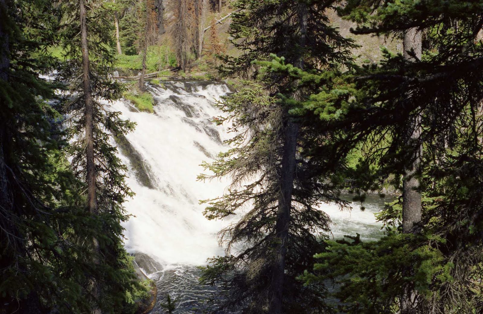
Lewis Falls Trail, Wyoming
Ten miles after driving into Yellowstone National Park through its southern entrance, you will cross a bridge over the Lewis River, from which Lewis Falls is visible upstream. Turn off the road after crossing the bridge and you will find that the beginning of the wide, well-trodden path to the falls is obvious. This is another waterfall that impresses because of its sheer water volume rather than its height; and it is also impressive because of its 60-foot width and because some of the trees around it still show signs of the fires that raged through Yellowstone 23 summers ago. The walk is ridiculously short (less than a tenth of a mile) and provides a perfect example of how a simple change in perspective can make a big difference in the way an object appears: The first picture below was taken at the beginning of the walk, while the second was taken near its end.


Pfeiffer Falls and Valley View Trails, California
In California’s Coastal Range is Pfeiffer Big Sur State Park, where these two trails combine to form a 2½-mile loop. Start on the Pfeiffer Falls Trail (PFT) and do not take the left hand turn onto the Valley View Trail (VVT) that you see early on. The PFT ascends through a redwood forest while following the course of a gently cascading creek. After seven-tenths of a mile it ends at Pfeiffer Falls, from which you will backtrack a short distance and then take the right fork to the VVT, crossing a pair of bridges in short order.
Take the next right turn you come to and follow it to the VVT’s northern terminus where the trail offers up this view of the Big Sur Valley. From here, turn around and remain on the VVT until it ends by emptying onto the PFT back at that junction you skipped at the beginning. By the end of this hike’s 2½ miles you will have experienced an elevation change of 450 feet -- big enough to count, small enough for the whole family to complete.

Rainy Lake Trail, Washington
This trail is remarkable in that it takes you to a high-altitude alpine lake in one of the most rugged and remote corners of America, but is easy enough that it can be completed even by the wheelchair-bound. The one-mile haul to the lake departs from a high point on the south shoulder of the North Cascades Highway; remains almost perfectly level the whole way; and on top of that, is paved. Once you reach the lake you will see that it is a sight to behold, surrounded by snowy, chiseled ridges and fed by ribbon-like waterfalls flowing down the slopes on the opposite side. Fishing is allowed. The trail is within Ross Lake National Recreation Area, which bisects North Cascades National Park, and its trailside signs are very informative. If you want to see a better shot of the view I photographed below, go here.


Great information for families! I am loving that photo! I'm all about getting children out into nature!!
ReplyDeleteGreat info, and not just for families with kids. Those of us who travel with older relatives or have family members with limited mobility are often looking for outdoor venues that aren't too strenuous.
ReplyDeleteThanks for the great posts! Very helpful information and makes me want to hike all four trails. I have hiked into Abrams Falls a few years ago with my Dad (now deceased) - and also hiked in to it from Abrams' Creek - which is a bit more rugged and more lengthy trail. Great hike though.
ReplyDeleteThanks so much for taking me on such a wonderful journey through these beautiful places, John.
ReplyDeleteAt 68 I can't hike like I use to.. but I certainly enjoyed looking over your shoulder.
Happy trails,
Pam
It's amazing, the amount of info you packed into this extremely informative entry. So happy to see some of these hikes. This is something I really miss, having stopped the camping yrs. ago, not with intention. Life throws a few curves but these trails sound doable even for me.
ReplyDeleteThanks for stopping by. Things are looking up for Bill and hopefully it will continue. He never appreciated his sight so much as now., me either.
Happy Trails, John, and your family.
BlessYourHearts